In addition to detailed recording of plant species on the sample plots, we also documented the marsh vegetation of Lake Cerknica from the air. Remote sensing with the help of a drone, or unmanned aerial vehicle equipped with powerful cameras, allows us to study larger areas in much less time. Stands of marsh vegetation are often very difficult to access, and such technical support is more than welcome. The entire area covered by the LIFE Tršca project is in fact more than three square kilometers.
Of course, the content of the aerial images must be regularly verified on the ground, as we need to “teach” the drone’s cameras what they are seeing – and many things still remain hidden from them.

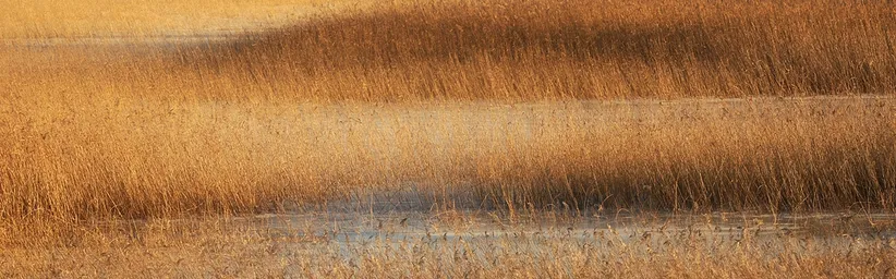
Along the Stržen riverbed and its banks grow various plant species adapted to constantly changing hydrological conditions. In the water, yellow water-lily (Nuphar luteum) dominates, with floating leaves and long stalks that follow the water level in the Stržen or in the lake. On the bank of the Stržen, in the upper part of the picture, we see dark stands of common club-rush (Schoenoplectus lacustris), which thrive best when the soil is flooded for most of the year. Behind them are lighter stands of common reed (Phragmites australis). Reed can easily grow on very dry soil, but is also unaffected by high water, making it perfectly suited to life at Lake Cerknica.
On the right side of the image, traces of mowing of marsh vegetation can be seen. In addition to water, mowing has a decisive influence on the vegetation structure, and therefore also on the success of reed growth. One of the goals of the LIFE TRŠCA project is to determine a management regime that will suit both reed and other stakeholders.

To connect the data collected on solid ground with those obtained from the air or even from satellites, we use an antenna that allows us to determine the location of a plot – or even an individual plant – with an accuracy of 1 cm. Without such an antenna, it would be very difficult to relocate the plots we are studying.

A view of the Vodonos sinkhole near Dolenje Jezero, which from the air looks like a true work of art. The varied terrain, meandering channels, and sinkholes create highly diverse ecological conditions, reflected in a mosaic of plant communities.
The contribution was prepared by the Faculty of Biotechnology.